
1. Trail Overview & What to Expect
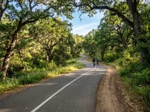 The Miner’s Ravine Trail is designed for accessibility, convenience, and safety. The main route features a 10-foot-wide paved asphalt surface complete with a painted center dividing line to keep pedestrian and bicycle traffic flowing smoothly. Alongside the asphalt path, runners and walkers will appreciate the 2-foot crushed granite shoulder, which offers a softer impact for joints.
With an average grade of less than 1%, the trail is mostly flat, making it ideal for strollers, wheelchairs, young cyclists, and long-distance runners alike. Because it follows the natural contours of Dry Creek and Miner’s Ravine, the greenway remains cooler than surrounding suburban roads during hot summer months, buffered by mature blue oaks, cottonwoods, and weeping willows.
Key Trail Statistics
- Distance: 6.36 miles (one-way continuous path)
- Surface: Paved asphalt with decomposed granite shoulder
- Difficulty: Easy / Flat grade (5% or less)
- Dog Friendly: Yes (must be kept on a standard leash)
- Allowed Uses: Walking, running, road biking, gravel biking, dog walking, and inline skating
2. Major Highlights Along the Route
Unlike standard urban paved paths, Miner’s Ravine Trail weaves together natural ecology, public art installations, and centuries of Placer County history. Here are the key stops you will encounter as you journey along the trail from east to west:
Miner’s Ravine Nature Reserve & Preserve
Located near the eastern end off Sierra College Boulevard, the 26-acre Miner’s Ravine Preserve is a protected wetland and flood control basin managed in partnership with Placer Land Trust. This restored ecosystem acts as a critical sanctuary for native wildlife, including spawning Chinook salmon during late autumn, river otters, egrets, and great blue herons. Interpretive signage along the loop trails explains local marsh vegetation and wetland conservation efforts.
Indigenous Heritage & Nisenan Grinding Stones
Long before gold prospectors arrived in Placer County, the indigenous Nisenan people lived along the oak-lined banks of Dry Creek. Near the central sections of the trail, visitors can view preserved bedrock mortars (grinding stones) carved into granite outcrops. These historic stone basins were used for centuries by Nisenan families to grind acorns into flour, offering a silent reminder of the land’s deep native roots.
Sculpture Park & The “Cosmos” Installation
As the trail approaches the Interstate 80 underpass, it passes through Roseville Sculpture Park. The centerpiece of this open-air gallery is Cosmos, a monumental red steel sculpture rising dramatically above the greenway. The park provides clean rest plazas, drinking fountains, and colorful modern artwork that creates a striking visual contrast against the natural riparian backdrop.
Downtown Roseville & Royer Park Connection
On the western terminus, the trail flows into the vibrant urban core of Roseville, terminating near Royer Park and Oak Street. Royer Park features shaded playgrounds, sports courts, picnic areas, and footbridges over Dry Creek, making it a natural stopping point to refuel with food and drinks in Downtown Roseville.
3. Key Trailheads & Access Points
Because Miner’s Ravine Trail features multiple formal parking hubs along its route, you can easily customize the length of your outing. The table below highlights the most popular access points:
| Trailhead Location | Best For | Key Amenities |
|---|---|---|
| Sierra College Blvd Parking Lot (East End) | Nature reserve access, quiet suburban starts | Paved parking, van-accessible parking spaces, interpretive signs |
| Sculpture Park / Eureka Road (Central) | Short walks, viewing public art, quick bike starts | Public artwork, rest plazas, shaded seating, nearby shopping centers |
| Oak Street / Royer Park (West End) | Families, post-hike dining, downtown commuting | Accessible parking, restrooms, playgrounds, direct access to Vernon Street cafes |
4. Tips for a Great Visit
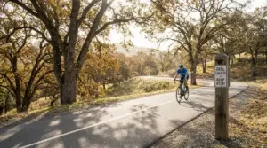
To make the most of your time on the Miner’s Ravine Trail, keep these practical local tips in mind:
- Practice Trail Courtesy: Cyclists should ring a bell or give a friendly verbal warning (“passing on your left”) when overtaking pedestrians on the path. Keep to the right half of the trail except when passing.
- Seasonal Timing: Spring brings lush green vegetation, blooming wildflowers, and high creek water levels. Autumn offers crisp air and vibrant gold foliage along the oak and willow canopy. Summer visits are best done during early morning hours before temperatures peak.
- Stay Hydrated: While water fountains are located at major park hubs like Sculpture Park and Royer Park, carry a water bottle for longer out-and-back rides or runs.
- Wildlife Awareness: Deer, wild turkeys, hawks, and songbirds are frequently spotted along the trail. Coyotes also inhabit the creek corridor, especially around dawn and dusk, so keep pets on a leash at all times.
Experience Roseville’s Green Heart
Miner’s Ravine Trail proves that you don’t need to drive deep into the high mountains to experience tranquil California wilderness. Whether you’re clocking training mileage on a bicycle or taking a calm evening walk alongside historic creek bed granite, this National Recreation Trail stands out as one of Placer County’s true urban treasures.