
From the high-alpine snowpacks of the Sierra Nevada down through the oak-dotted canyons of the California Mother Lode, water shapes every corner of Placer County. While major recreational hubs like Lake Tahoe, Folsom Lake, and the main confluence of the American River draw large crowds during warm summer weekends, the county’s true aquatic magic lies tucked away in hidden ravines, forested river forks, and backcountry creeks.
For outdoor enthusiasts willing to lace up their hiking boots and venture beyond the primary tourist thoroughfares, seeking out Placer County hidden waterfalls and secluded swimming holes offers a refreshing glimpse into Northern California’s untouched natural beauty. This comprehensive guide highlights the best off-the-beaten-path aquatic adventures across the foothills and national forest lands, complete with essential trail safety guidelines and ecological preservation tips.
The Hidden Gems of Coon Creek & Hidden Falls Regional Park
Tucked away in the rolling oak woodlands northwest of Auburn, Coon Creek and Deadman Creek carve through dramatic granite ravines. While the park itself has gained regional popularity, its extensive 30-mile trail system hides quiet stream access points and cascading waterfalls that remain peaceful outside of peak hours.
Coon Creek & Canyon View Falls
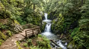
While most day-trippers congregate at the primary observation deck overlooking the 30-foot main cascade, continuing along the Poppy Trail and Quail Run loops reveals quieter, multi-tiered stairstep waterfalls. Following the creek down-canyon leads to natural granite pools framed by wild lavender, native ferns, and towering bay trees. The shaded canopy along Coon Creek keeps temperatures comfortably cool, making it an ideal spring and early-summer retreat.
Visitor Note: To prevent overcrowding and preserve wildlife habitats, parking at Hidden Falls Regional Park requires an advance online permit on weekends and major holidays. Planning your visit on a weekday morning ensures a quiet, uncrowded experience along the trails.
Backcountry Cascades: North Fork Falls at Emigrant Gap
For a true mountain adventure deep within the Tahoe National Forest, head up Highway 80 toward the higher elevations of Emigrant Gap. Here, the North Fork of the North Fork of the American River forms North Fork Falls, a breathtaking mountain cascade spilling over polished granite cliffs into a deep, crystal-clear swimming basin.
Unlike foothill creeks that slow down by mid-summer, this high-elevation water source stays cold and vibrant well into late August. The surrounding granite ledges offer natural sunbathing spots surrounded by aromatic incense cedars and sugar pines. Accessing the falls involves navigating unpaved forest service roads and a steep, short scramble down to the riverbed, making sturdy footwear an absolute necessity.
Exploring the Canyon Swimming Holes of the American River
The vast Auburn State Recreation Area encompasses over 30,000 acres along the North and Middle Forks of the American River. While popular river access spots near the Foresthill Bridge draw crowds, hiking further upstream along historical mining footpaths unlocks pristine, secluded river pools.
Yankee Jims & Shirttail Canyon
Located near the historic timber settlement of Foresthill, the canyon surrounding Yankee Jims Bridge features deep emerald pools where Shirttail Creek feeds into the North Fork of the American River. The steep canyon walls provide natural shade during hot afternoon hours, while smooth river rocks create ideal resting perches. The swirling, clear water invites calm wading during late-summer months when river currents drop to safe levels.
Stevens Trail to the North Fork
Starting near the historic town of Colfax, the Stevens Trail descends 4.5 miles through oak woodlands, chaparral, and historic gold mining cuts down to the bottom of the North Fork American River canyon. The trail terminates at a wide, gravel river bar featuring secluded swimming holes, natural rock slides, and sandy beaches that are completely inaccessible to vehicle traffic.
Essential Safety Guidelines for High Sierra Streams & Rivers
Exploring wild waterfalls and unpatrolled swimming holes comes with inherent natural risks. Following established safety protocols ensures a fun and injury-free outing:
- Beware of Frigid Snowmelt: Mountain streams and river pools in Placer County are fed directly by Sierra Nevada snowpack. Water temperatures can remain dangerously cold (often below 50°F) well into early summer, creating a sudden risk of cold-water shock and hypothermia even on 90°F days.
- Check Flow Rates Before Swimming: Spring runoff turns serene creeks into rushing torrents. Never attempt to wade or swim above a waterfall drop or enter fast-moving river currents. Always inspect downstream conditions before entering any natural pool.
- Watch for Slippery Granite: Wet granite rocks and river stones are coated in microscopic algae, making them as slippery as ice. Avoid walking along the wet edges of high waterfall cliffs, and wear grippy rubber-soled water shoes or sticky-rubber approach shoes.
- Never Dive Headfirst: Underwater boulder formations, submerged tree branches, and shifting gravel bars change continuously with seasonal floods. Always enter unknown water feet-first to gauge depth and identify underwater hazards.
Practicing Leave No Trace & Responsible Trail Etiquette
Placer County’s riparian corridors are fragile habitats that support diverse wildlife, including black bears, river otters, native trout, and nesting songbirds. Preserving these pristine aquatic sanctuaries requires collective stewardship from every trail user in accordance with guidelines from the Placer County Parks and Trails Division:
- Pack It In, Pack It Out: Bring a dedicated trash bag and haul out all garbage, food scraps, fruit peels, and pet waste. Leaving no trace ensures these wild spaces remain pristine for future hikers and local wildlife.
- Use Environmentally Safe Sunscreen: Traditional chemical sunscreens can leave an oily film on standing water pools and harm aquatic life. Opt for mineral-based (zinc oxide) sunscreens when swimming in natural creeks and river basins.
- Respect Private Property Rights: Many trailheads border working cattle ranches or private foothill properties. Always stay on designated public trails, obey posted signs, and close livestock gates behind you.
- Keep Dogs Leashed Around Water: Fast river currents pose severe hazards for dogs. Keep your pets on a leash near steep drop-offs and turbulent water to keep them safe.
Discover Placer County’s Wild Side
Placer County’s hidden waterfalls and secret swimming holes showcase the incredible natural diversity of Northern California’s foothill and mountain landscape. By planning ahead, respecting seasonal river conditions, and leaving these wild environments cleaner than you found them, you can enjoy an unforgettable summer season exploring Placer County’s coolest, most refreshing natural treasures.